Let us share with you our understanding of this beautifull map and the points we cannot understand.
We thank you for the help and the additional information your knowledge of Japanese history could add to our initial inquiry
Updated on 8/1/2025 and 30/1/2025 thanks to Matteo Vassout.

The Edo period in Japan has seen a dramatic increase in domestic travel and a concomitant production of maps of all kinds for the various travelers: daimyo, soldier, monk, pilgrim, merchant, vacationist…Usually, maps are easy to read and use. Some, however, contain unexpected, hard to understand information.
This is the case for this map of the « Road to Aizu », a famous domain in Tohoku, and it raises several questions we tackle in this blog, hoping for your help!
More than a simple regional map, this triptych posesses an artistic dimension revealed by the network of roads litterally climbing up and down mountains across the whole scenery.

The Aizu domain is located about 280km north of Edo (Tokyo). It has a rich history and has been closely associated to the Tokugawa shoguns during the whole Edo period.
This map was initially a folding road map, but it was later made into a triptych, certainly for decorative purposes. It shows all usual information expected on a map (title, legend, orientation, date) and on a woodblock print (artist, publisher, date/censor seal).


When a modern map covering the same area is placed upon the Aizu map, one checks that the relative positions of the 6 castles in the region correspond well enough in the two maps. Yet, the artistic look of this map does appears to be rather unique. Also, care has been taken by the artist to place the Aizu castle in the triptych exactly on the North of the compass rose.

Topography Valley Coast : Tohoku is well known for its beautiful countryside with mountains, lakes, onsens… Large valleys with a thriving agriculture have a North to South orientation, as do the main roads with offshoots towards the major harbours.

The triptych, however represents only a small portion (60kmx120km) of the Tohoku region (160kmx600km).
One might ask whether this Meiji map is a part of a set of similar maps covering other parts of Tohoku, but none was found so far. Does it mean there was a special interest for the Aizu region and in this road?

In addition to the Aizu map, the triptych shows 6 horizontal cartouches with names of places and what appear to be distances from Edo. One block includes the names of 4 castle cities shown in the map, including Aizu, and has been enlarged. But none of the other places of this list is in the Aizu region.

When this series of cities is placed (red spots) on a modern map, some itinerary from Koga to Kubota does appear, with increasing distance from Edo as would be expected. The section up to Shirakawa would correspond to the Oshu Kaido. But is this the Aizu-do of the title?

Places listed in the 6 blocks have been represented as colored spots on the map of Tohoku, with one color by cartouche.
They pretty much cover all of the region, far beyond Aizu, but what is the connection between these lists and the actual map of the triptych?

This cartouche of places from Tanagura to Matsumae might be somewhat connected to the Sendai-Matsumae-do developed by Tokugawa Yeyasu to ease the travel of shogunate officials to the North Tohoku. Distances increase as expected. The 3 question marks correspond to places we could not locate on modern map. We welcome proposals.

All places listed in this block belong to the coast of the Japan sea.
This itinerary from Itoigawa up to Murakami looks like the northern section of the Hokuriku-do.
Unfortunately, the distances from Edo do not seem to be coherent. What do they say?


Places in this cartouche underline a shorter itinerary from Takasaki to Nagaoka which might correspond to the Mikuni Kaido, with coherent distances from Edo.

Overall, most cartouches may be interpreted as describing some itinerary north of Edo and into Tohoku.
Yet, in one (blue dots) of the 6 sets the distances between places do not show a meaningful trend. Why?
More critically, it appears that there is no obvious relation between the actual Aizu road map of the triptych and nearly all places listed in the 6 horizontal blocks « added » to the two left panels. Why are they here?

The other side of the mountain is the territory of Uesugi's domain, and there are many paths. Here the banks of the Tsugawa river are in Echigo province.
As you descend from the green of the Kagura forest on the top of Mt.Mikagura-dake , you will find yourself on the road to Aizu from Echigo, there is the mountain pass which is more like a gentle slope. .....
The road from Tsugawa is the main road to Echigo.The other side of this mountain from the territory of Echigo belongs to Dewa province's territory
(Kindly translated by I. Nagy)
One would hope the text on top of the left panel would shed some light on this question.
Unfortunately, it is only a simple and poetic description of the vicinity and the topography near Aizu.
It has nothing to do with the whole Tohoku region.
Another mysterious feature about the triptych is that it was produced in 1869, less than a year after the end of the civil Boshin war during which the Aizu domain was on the losing shogun side.
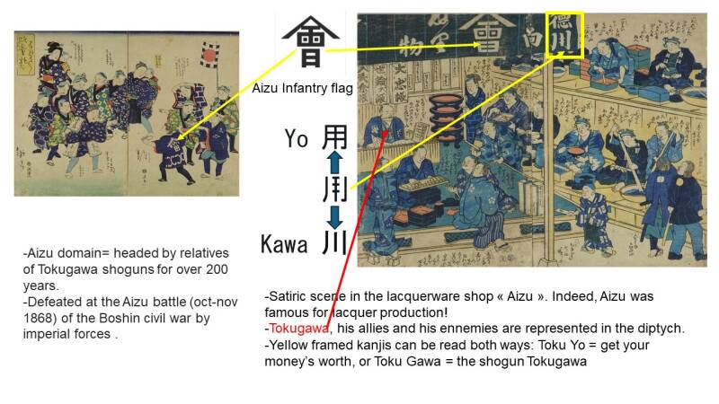
The Aizu domain was involved during this civil war to such an extent that it was directly represented in several of the numerous satirical diptych prints produced anonymously during the war.
Honorably beaten at the battle of Aizu in 1868, the head of the clan was later awarded the administration of the famous Nikko shrine by the Emperor. Is it a consequence that the Aizu region was placed back in the forefront through this triptych, as a public gesture of national reconciliation, or what?
The importance of the Aizu domain during the 1868-1869 Boshin war is well shown in the two following satirical woodblock prints.
At this stage of our investigation, we still have several unanswered questions for which we would like to have your insight:
- What is the connection between the map itself which is limited to the Aizu region and the 6 cartouches with cities from all over Tohoku?
- Do the 6 lists of places in the horizontal cartouches represent main historical routes in Tohoku?
- How to explain the seemingly illogical distances of places between Itoigawa and Murakami (dark blue dots) from Edo?
- What could be the reason for “celebrating” Aizu with a specific and artistic map right after the Boshin war during which the Aizu domain was supporting the shogun who was defeated?
We thank you for any hints, contribution and or proposal of correction to keep progressing in our understanding.
Research and writing: Francis Minvielle
Support and preparation of the French version: Franck Girard
Very special thanks to:
- Imre Nagy
- Lucienne Parkan
- Horst Graebner
- Francine Esterez Minvielle (photo credits)
- Asian Art Forums
- Ukiyo-e Discussion Forum
for their contribution to help us achieve this first level of understanding
Comments contributed by Matteo Vassout, young researcher at the Ecole du Louvre, specialised in japanese and european prints, regarding the historical background. 30/1/2025
As for the date of publication and the reasons which may have led to representing the Aizu domain in 1869, the clan at the head of the domain was at the center of political attention in the summer of 1869.
At first the territory of the clan was confiscated by the Meiji government, the head of the domain Matsudaira Katamori was imprisoned in the Tottori region, and in May 1869 the retainers who took full responsibility were executed in Edo by public beheading, along with other councilors involved in the Boshin War.
The Aizu territory is divided, part is transferred to the Mutsu province. The Meiji government set up its civil affairs office in Wakamatsu Castle to somehow reclaim it. It was also only in June 1869 that the Ezo Republic ended after the surrender of Enomoto Takeaki (the last representative of the Ōuetsu Reppan Dōmei coalition of which the Aizu domain had been one of the founders), putting an end to the wars in northern Japan.
On the other hand, the Matsudaira (former head of the Aizu domain) were quickly rehabilitated in the summer of 1869 and were allowed to become the managers of a new domain further north under Meiji obedience obviously.
These different events in 1869 around the Aizu domain perhaps justify such an undertaking of territorial description. As well as the inclusion of Aizu in a broader geographical context. I admit that I do not know enough about the military campaigns that preceded the advent of Meiji and the campaigns of the Tōhoku wars, but it is possible that this map also refers to these political and military developments of the period to allow us to grasp the issues on a map.
However, it should be kept in mind that there was a sufficiently large movement of publishing documents critical of the new power in place in 1868-69, that a law on publication was passed in 1869, requiring all publications to go through government pre-publication committees. This law was used as a method of control of the publishing world and led to the imprisonment of a certain number of publishers in Edo.
This print could also be part of an edition close to the last supporters of the Bakufu in Edo highlighting the figure of these last resistance fighters of the Aizu domain.
I am not sure I can decide.
Add comment
Comments